
The Piri Reis Map of 1513 is not Historically Accurate
There are many, especially in the media that believe this ancient map is uncannily accurate. The problem: it's accurate for its time but not for today. That is, if it's real.

Appears to be Accurate
At first glance, The Piri Reis Map of 1513 appears impressive. The lines drawn on it seem to give a dimension like no other work of cartography of its time. And, surprisingly, the places it give the impression that it matches actual geographical features. However, in the case of this map, looks are deceiving.
What appears to be an accurate depiction of the world as it was known in the 16th century is as accurate as the mythical islands it names. And under scrutiny in the 21st century, the map is far from being accurate, let alone genuine.
What is the Map?
The Piri Reis Map was supposedly created by an admiral of the Ottoman Navy in the early 1500s. However, it was only known to the world since the early 20th century when it was found in a palace being converted into a museum in Turkey.
Upon its rediscovery, there had been speculation on how Piri seemingly got the details on the map fairly accurate in terms of the recording the Americas without ever sailing there.
As often in these cases, the lack of recorded evidence of him sailing there has been ignored by some. True believers in the map genuinely believe he must have sailed there and was able to map the area.
However, the part that mystifies many is the assertion of large landmass he had drawn at the bottom of the map.
Other more plausible beliefs is that he took existing maps from Spanish and Portuguese explorers and created the map from their record.
However, the part that mystifies many is the assertion of a large landmass he had drawn at the bottom of the map. Over the years, many speculated that somehow he knew about Antarctica. And, due to this, many conspiracy theorists (especially those that support the presence of the Antarctic Pyramids) believed that this map was accurate and that it not only showed the southern most continent. It revealed that it was not covered in ice during the 1500s, let alone being there more that 300 years before it was discovered.
Its Depictions Don't Match
The map may do a good job of showing portions of North and South America, but its depictions has numerous flaws. For starters, its depictions of the Caribbean Islands have bizarre omissions and added details.
To be succinct, it doesn't match the features that are now known about the area. In some cases, islands that don’t exist such as Antlia are added while others, such as Cuba, are excluded.
While it does a fair job on the coast of the Brazil, Europe and Northern Africa, the strange eastward curve of South America’s southern features gives the map a very distorted appearance.
Some have claimed that the southeastern portion of South America was supposed to represent Antarctica. Even if it is, it is way too far north, and is connected to the South American continent. In addition it barely shows known features – such as ice caps, let alone showing it connected to the South American mainland).

Baffling Map
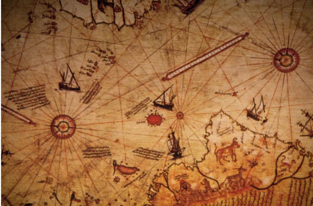
Since its discovery in a Turkish palace in 1929, The Piri Reis Map has been the focus of debate by researchers in cartography. Piri Reis – translated as Admiral Piri – was an admiral and cartographer of the Ottoman Empire. He created his map on a piece of gazelle skin and was believed to have used existing maps and charts from Spanish and Portuguese explorers of the early 1500s. Included in the collections were those supposedly created or used by Christopher Columbus.
The map was typical of its time; it was a Portolan chart. The lines are not longitudes or latitudes. Instead they are azimuths. According to Encarta Dictionary, it is the angle measured from north, eastward along a horizon to a point where a vertical circle through an object that intersects the horizon. Often an azimuth will have a center where it begins. The map has compass roses in various places acting as these centers.
When it was found, it became a hot topic of debate among cartographers. Many believed that it could be the most important map since it was rumored or believed to use the “lost” charts of Columbus.
But, there was a slight problem with this map; it appeared to be only a fragment of a larger map. Many were not sure if the distorted portion of North America and the Caribbean was supposed to represent Asia – since it was the original destination for numerous explorers of the time.
Map Enters the Conspiracy Theories
Later, in the 20th century, the map slipped out of the hands of cartographers became the realm of the weird and extraordinary world of pseudo-science. Eric van Daniken, writer of the Chariots of the Gods? and avid supporter of the ancient astronauts theories believed that it was proof that the ancient people of Egypt were helped by space aliens.
These arguments, however, take away from the validity and accuracy of the map.
Part of this belief was based on his own “findings” that the azimuth of the map can be centered in Cairo (however, his interpretation of his was put to the test. It failed to match modern maps or charts when Cairo was made the center of the azimuth lines).
Another researcher, Charles Hapgood, claimed in his 1966 book, “Maps of the Ancient Sea Kings” that the map proved that there was pre-Columbian exploration as well as evidence that Antarctica was once ice-free in recent history. Like van Daniken, his theory couldn’t be proven.
It Doesn't Hold Up to Scrutiny
These arguments, however, take away from the validity and accuracy of the map. The map itself has flaws in the configuration of certain regions. The Caribbean’s flaws may reflect Columbus’ own errors; however flaws such as the fact that the map does not fit an azimuthal equidistant projection brings into question its validity as a workable map. In other words, even the lines and measurements don’t match when calculated with the math and configuration of its time, or when it is computed into modern cartographic terms.
There are other features that may challenge the map’s authenticity. Historically, this map wasn’t known to have existed until 1929 when the Topkapi Palace in Istanbul, Turkey was being converted into museum. This was when it was discovered by Halil Ethem.
Another item that brings the map into question is the language it was written in. It used Turkish letters. In the 16th century, Turkey, then the seat of the Ottoman Empire, used Arabic writing.
Also, some features of the map are suspicious. The map shows the Andes in South America. This mountain range was not known to Europeans at that time.
The map does get some things right, however. The scaled distance and position of South America’s Brazilian Coast in relation to Africa is remarkably accurate. Still, this map is far from perfect; that is, if it is real, in the first place.

Work Cited
- Hapgood, Charles Maps of the Ancient Sea Kings (1966)
- Raymond Clemens: "Portolan Charts": Beinecke Rare Book & Manuscript Library (July, 2022)
- Beth, "Piri Reis Map - How Could a 16th Century Map Show Antarctica Without Ice?": Ancient Origins.net (Sept.2019)
- Erich Von Daniken: Chariots of the Gods?; Penquin Random House (1968)
About the Creator
Dean Traylor
I wrote for college and local newspapers, magazines and the Internet (30 years). I have degree in journalism, masters in special education (and credentials), and certificate in screenwriting. Also, a special ed. teacher (25 years)
Keep reading
More stories from Dean Traylor and writers in History and other communities.
Angry Writer Misinterprets Trump’s Immigration Ban: A Look Back
Everybody Knew What it Meant Nobody should have been fooled. The intentions for the executive order, which placed a temporary ban on immigration to the United States, targeted Muslims. Even its legal jargon couldn’t hide its intentions.
By Dean Traylor2 months ago in History
Year 1824 Fun Facts, Trivia, and Historical Events
This quick read presents a collection of fun facts, trivia, and historical events from the year 1824. Discover the year’s top news stories, most influential people, historic firsts, famous birthdays, retail prices, and much more.
By Gregory DeVictor4 days ago in History


Comments
There are no comments for this story
Be the first to respond and start the conversation.